Appendix 1. Setting and Boundaries
A1.1. Context
The Management Plan Section 4 deals with Settings and Boundaries and this Appendix (1 – Setting and Boundaries) contains a summary of the information produced in support of it. WHS expansion and the proposed reviews of inner and outer setting are subject to agreement of the draft Management Plan following consultation. If agreed, the information in this appendix will provide a starting point for further analysis.
Section 7 of the Management Plan covers conservation of the fabric of the WHS and Sub section 7.12 identifies the need to understand and conserve the WHS and its setting. Key characteristics of the landscape, townscape and streets are also summarised in this Appendix.
Since the 2006 Management Plan there has been significant benefit from the expansion of the WHS to include Palace Green and the production of a suite of conservation management plans (CMP) for buildings and open spaces together with a condition survey of the Castle Walls.
The planning context continues to change and proposals in the operational documents of core stakeholders may also have to be revisited to accommodate any new statutory change. The WHS Management Plan as a working document for partners will need to respond to those changes whilst addressing its core objectives. The context of the WHS has also been affected by the impact of revised central government policy and guidance through the National Planning Policy Framework (NPPF). The replacement local plan (County Durham Plan) is under review. A Durham Neighbourhood Forum has been established to prepare a Neighbourhood Plan for an area that includes the inner city and its setting. In addition, UNESCO’s operational guidelines have been updated and various advisory papers issued by UNESCO and ICOMOS.
This appendix starts with the 2014 Boundary review and reference to other reports and identifies support information on the potential for boundary change and need for a buffer zone. This is followed by further information supporting scoping for extending the WHS boundary and describing inner and outer settings. It also describes key aspects of WHS character that would also be of value in assessing new development.
A1.2. 2014 WHS Boundary Review
The WHS Committee updated its boundary review in June 2014 and this was based on an initial visual survey to scope potential WHS physical boundary definitions. The conclusions were that the current boundary does not fully capture all of the attributes of the site in support of the site’s OUV and that the ‘immediate setting’ (See Plan A), as defined in the 2006 Management Plan 1, provides a basis for further scrutiny.
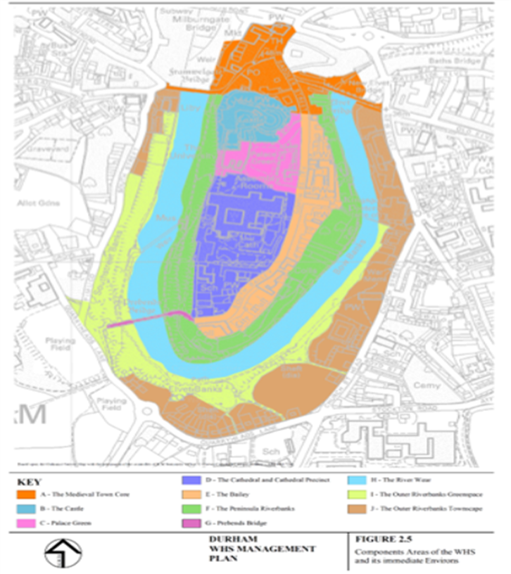
Plan A - The components of the immediate setting of the WHS as defined in the 2006 Management Plan form the basis for the current recommendation for an extended WHS Area with the exception of most of the town core and outer riverbank
Of particular concern was the failure to include all of the defences, including the outer walls and the riverside gorge. It was acknowledged that emphatic and detailed reasoning would be required to form a compelling case for any changes and revised boundaries. The current WHS boundary cuts through the course of the outer walls of the site. The need to reconsider the formal designation was identified in the Castle Walls Survey and Conservation Management Plan (CMP)2.
The following sections summarise the various characteristics of the WHS and its immediate setting that help shape suggestions for omission of a buffer zone and description of setting or WHS expansion. The review format follows topic headings from the UNESCO Operational Guidelines 2013 and particularly the Nara document on authenticity 3. The concern is with the degree of authenticity and also risk and management.
A1.2.1. WHS and Immediate Surrounds - Use and Function
River Wear Gorge
The River Wear Gorge looping around the Peninsula has fulfilled a range of functions reflecting the evolution of the Castle, Cathedral and their associated buildings. Its original steep sides are preserved in the remaining cliff at the edge of St Oswald’s churchyard on the outer riverbank and demonstrate the significant original defensive value as a steep sided moat. The rest of the inner and outer riverbanks now illustrate this defensive use of the river but as altered by the quarries that provided stone for construction and the weirs that fed water to mills. The weirs provided a defensive depth of water in summer months and the mills with a source of energy. The riverbanks’ current form was partially determined in the late 17th century, then shaped more significantly in the 18th century and further modified in the 19th century. This involved the creation of wall walks, gardens and orchards and the repositioning of Prebends’ Bridge followed by the creation of more extensive riverside walks. The garden and walks are now partially obscured by tree growth incorporating the original plantations and principally resulting from natural regeneration. The river and its banks are an integral part of the development of the WHS. They remain an authentic demonstration of the physical expression of spiritual and secular power and capture the essential physical area supporting the visual drama and romantic beauty of the Castle and Cathedral.
The Inner Historic City
While no longer exhibiting the same degree of historic integrity as the WHS, the city lying at the foot of the WHS originally evolved with it. This was at least until economic growth gave the city a means of support for development outside of the control of the church or closely related to its work. The historic river crossings, the development of the Market Place and mills were all dependent initially on church patronage. The streets of the City form the approaches to the WHS and include what would have been the pilgrimage routes to the Cathedral used over an extensive period. Accommodation would have been provided for pilgrims and the Market Place acted as a centre for trade. These functions grew alongside the WHS. The City’s economy developed during the 19th century to include mining, manufacturing and commerce. The impacts of the mid-19th to 21st century change are more clearly seen outside the core area of the WHS and the historic bridges, extending along the historic radial roads.
A1.2.2. WHS and Setting - Location and Setting (Form & Design)
Peninsula and River Wear Gorge
The river created the Peninsula and its potential as a defensive site for the Cathedral and Castle. Recognition of the true defensive extent of the WHS and the area containing the remains of the landscape that developed with the WHS is needed. It is a historic ‘leisure’ landscape that was formed on a functional working infrastructure but has since evolved into the internationally recognisable setting of the WHS. This provides the basis for the romantic setting of the WHS as currently defined. The Lighting and Darkness Strategy 4 for the City recognised the role of this area and need to preserve the unlit night setting of the Castle and Cathedral. This strategy allows the lit buildings to reinforce their dominance over the city and beyond.
The Inner Historic City
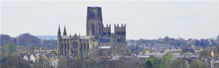
The historic street patterns and, to a significant extent, the building plots of the city centre remain the foundation of the current urban grain within the central core of the city. Within this area the built form has predominantly remained traditional, consisting of structures with pitched roofs and fragmented heights following the topography of the city in generally harmonious materials. This has created a unique and appropriate townscape setting for the WHS and its key buildings. Outside of this area, while there are historic assets, the built form moves away the traditional. Buildings sit alongside open spaces and the riverside, both of which offer historic views into the WHS and are relatively unaltered except by extensive 20th century tree growth. The later externalised and separated growth of Durham has not destroyed the valuable relationship between the townscape setting created by the historic city and the massive and dominating Cathedral, Castle and associated buildings.
The topography of the city blocks views from and to the WHS in some historic sections of the city. If visual impact is the sole factor for assessment of the inner setting, not all these areas would be drawn into it. However, other points of relationship, including their function as historic approaches, provide other close cultural ties with the WHS.
Of particular importance is the Wear Valley as it enters the City from the North and East. This now provides the separation of the City from its 20th housing estates and defines the boundary of the historic city core. This is important in reducing the apparent extent and scale of the built area and emphasising the scale and dominance of the WHS buildings.
Views
Significant views include:
- Pilgrimage and historic approaches
- Defence
- Hills and open spaces
- Buildings and structures
Pilgrimage and Historic Approaches
The inner setting area contains the three historic points of access to and from the historic city – down through Claypath and over the Elvet and Framwellgate Bridges. The pilgrims’ approach into the city is partly speculative but can be tied to the roads approaching these entry points. Durham Cathedral has remained a major centre for pilgrimage to the shrine of St Cuthbert, despite the dissolution of the monasteries under Henry VIII. It continues to act as a centre for pilgrimage offering continuity of use and religious significance.
Claypath
Routes eastwards from the coast ran down through Gilesgate and directly into the Market Place along Claypath. The original continuity of this route is disrupted by A690 and its cross city cutting and bridges. Buildings obscure sight of the WHS on some sections but a sequence of views can still be experienced.
Elvet
Routes from the south cut through the ridge that terminates at Maiden Castle (an Iron Age Hill Fort) and then ran through Hallgarth St and Shincliffe Peth. In addition, the potentially earlier route south along South St that by-passes the river crossings offers high quality views as it runs around the foot of the hills to Shincliffe Peth.
Framwellgate
Roads from the north and west approach Framwellgate Bridge through Framwellgate Peth and Crossgate Peth. A sequence of views is experienced from Allergate and down Crossgate. Views from Framwellgate Peth into the city remain but have been altered by the extent of 19th and 20th century development.
Defence
Manifestations of power and the defensive nature of the WHS are clearly visible when viewing the site. These include the inner and outer defensive walls of the Castle; the Castle’s gatehouses and the natural defences of the peninsula’s steep river banks.
Hills and Open Spaces
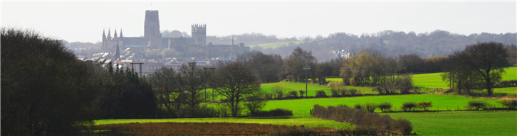
These are very significant in the relationship to the historic city core and in the City’s relationship to the WHS. They can be considered to form the majority of an inner setting area lying beyond the immediate setting to the WHS. The latter is reviewed for potential for definition as either part of a buffer zone or for expansion of the WHS boundary. The two key river spaces, the Racecourse and the Sands, are now configured for sports/open space use having evolved from their possible water meadow/riverside field origins. The Racecourse offers a range of views approaching the city and importantly includes foreground buildings to the WHS showing it in context. The Sands area and Kepier offer some Cathedral tower views and on the opposite bank the riverside also provided the historic route out to Finchale Abbey. It forms part of the important view corridor from Frankland Lane towards the WHS
The slopes of the inner ridges offer a range of views with landscape to the foreground expressing something of the original relationship between the small historic City and WHS. They are important for artists and photographers who depict the WHS. Key viewpoints are at Whinney Hill, Mountjoy, Observatory Hill and Crook Hall. Trees obscure the view from Maiden Castle and also at Flass Vale where there were 19th century views across the city to the WHS.
Buildings and Structures
19th and 20th century development has created a range of viewpoints of the WHS. The 19th century station, its approaches and the viaduct offer panoramas across the city for train passengers and visitors. This is combined with the 19th century creation of North Road that opened up direct vistas to the Castle. The 19th century Baths Bridge and now the more recent bridges - the A690, Pennyferry and Kingsgate footbridges, the Milburngate and Elvet road bridges, all offer views to the WHS. Walkways and stairwells to the two retail centres, the Gates and Prince Bishop’s also offer new viewpoints to the WHS.
The 19th century development of Wharton Park created the Battery, specifically placed for WHS views and mimicking the style of the Castle Keep. A recent hilltop sculpture in the Park, The Way, was sited to frame a view of the Cathedral.
Many buildings offer views to the WHS particularly from their upper stories, amongst the more prominent are the University buildings on the hillsides which have created new vantage points. Milburngate House, particularly its central tower building has also generated a range of city wide/WHS views.
A1.2.3. WHS and Immediate Surrounds - Spirit and Feeling
The River Wear
The paths and bridges within the riverbanks area provide entry into a unique and distinctive landscape that intimately connects with previous historic use and with the various buildings and structures of the WHS. They provide a calm and reflective environment that supports the spiritual role of the Cathedral and enables the visitor to access the spirit of the past without the disruption of the present.
The importance of the Cathedral’s role as a place of pilgrimage and its impact on pilgrims as they neared the end of their journey is still to be felt as an experience in the potential expansion area of the WHS and the historic city and its inner setting. A pilgrimage leaflet is available from the Cathedral.
The Historic City
Where the historic influence in the built form is strongest the approaches to the WHS offer the most recognisable relationship to the WHS, providing a sequence of views and experiences moving towards the Cathedral and Castle. In the more visible sections, particularly at the foot of the Castle, they offer an appropriate backdrop that both looks and feels like a reflection of the medieval city. Despite evolution across an extended period, the areas of fragmented urban grain with the greatest historic relationship provide an authentic experience of the way the City was and its domination by the Castle and Cathedral. This contrast offers the most immediate experience of the visual drama of the Castle and Cathedral outside the area suggested for potential inclusion in an expanded WHS.
A1.2.4. WHS and Immediate Surrounds - Integrity
Cohesiveness & Adequate Size
It has been a consistent strand of commentary through reports on the WHS that the boundary to the WHS does not capture the site’s essential entirety. Expansion to include Palace Green usefully united key elements but the site boundary cuts through otherwise recognisable features that provide essential support to the attributes of the WHS and the OUV. The proposed expansion area is clearly defined physically by the river on the gorge side with its landscaped areas. This reflects the actual defensive extents of the site and the area of greatest historic integrity. Functionally, the character of this area breaks at the two historic bridges – Framwellgate and Elvet.
Intactness - City
Although when considered as potential for WHS designation, the city itself does not provide sufficient historic integrity because almost all of it is post-Norman and rebuilt or remodelled through to the present day. However, there remains much potential for it as a defined setting and valuable townscape backdrop and the historic city core has its own substantial integrity in contrast to the ICOMOS view5 of its value. This value lies within the scale and nature of its buildings, its reflection of the historic built pattern and the preservation of intervening open spaces.
There are three formative elements helping to shape the city:
- The core where key changes have been relatively limited;
- Areas of change through the 19th century reflecting economic development in County Durham and;
- The 20th/21st clustering of new road, municipal, government, university and retail/commercial/leisure buildings.
The University in its expansion out from the WHS and Peninsula has established a substantial presence on the riverbanks at Hild and Bede College and on the slopes at the edges of the city at the Science Site and hillside colleges. Durham’s major residential, business and retail park expansions have effectively been masked from the city core by extending west/north and east onto the plateau areas of the Wear Lowlands6 separated by the surrounding ridges and slopes.
Within the core there is a range of 19th-20th century extensions and rebuilding that are often plain and unsupportive of the street character and have limited value for the WHS setting. Within Silver St the cluster of three discordant blocks Nos. 7-8 and 4-6 Silver Street and 17 Market Place alter the street character and lack pitched roofs but their height has not impacted on the views across to the WHS. The 20th century blocks flanking Framwellgate Bridge affect the character of the Bridge in relation to the WHS and have some negative impact on the quality of a key view.
There were 19th century changes within the Market Place including the indoor market building, St Nicholas Church and bank buildings, but these are consistent with an appropriate scale of organic historic change in the context of city views and are generally considered to be attractive in their own right. Elsewhere, greater levels of change provided new views and redefined parts of the historic core, especially in North Road, the County Hospital and the Station with its dominating Viaduct.
There is effectively a ‘new’ city quarter that has formed adjacent to the A690 where it cuts through the city with twentieth century bridges, including the complete redevelopment of historic Milburngate and Framwellgate. The scale of this development is disproportionate in comparison to the grain of the historic city and continues north of Milburngate Bridge7. Overall this has diminished the quality of views from the WHS and the Milburngate Bridge has cut through the historic city. However, this impact had been reduced through the use of traditional architectural forms in the current Gates Centre and the Highgate housing scheme. The combination of the A690 cutting, and new Elvet Bridge, followed later by the Prince Bishops Centre, has had substantial impact through its scale and building design. The spread of larger University buildings along Old Elvet on the riverside also has altered the quality of the view but Dunelm House and Kingsgate Bridge are generally considered to provide good examples of twentieth century development.
Open spaces have been preserved through the city and within the more major developments, partly due to topography but also as a result of positive ownership, development and local support. The riverside extends to the broader spaces of the Sands and the Racecourse both of which have important links to Durham’s past. The historic churchyards of St Margaret’s and St Oswald’s now form part of the inner historic core area but directly relate to Durham’s historic boroughs that originally lay outside the city core. Margery Lane allotments are on an historic quarry site and with other outer riverbank fringes form the setting to the historic core and encircle the proposed WHS expansion area.
The slopes and ridges of the inner bowl beyond the principal built up areas have retained their generally open appearance. Tree planting and natural regeneration obscure the range of colleges, University buildings and Durham School grounds. There are key historic sites at Flass Vale, Wharton Park, Sidegate, Crook Hall and Maiden Castle. These slopes and ridges help to define and shape views across Durham and the WHS and contain the inner city without the intrusion of Durham’s major post 19th century growth. They extend further out into what can be considered the outer setting of the WHS along the river at Pelaw Woods and beyond, where there is a requirement for greater scrutiny of definition.
The historic core, open spaces and hillsides together demonstrate substantial essential intact qualities that support the integrity of the WHS.
Intactness – River
The river remains locked in its post Ice Age bed, held in place by the rocks it incised through. The cliff at St Oswald’s is the preserved remains of its original form. The riverbank areas have been clear of built development since the Cathedral and Castle were created when the last natural tree cover was either removed or the earlier practice of removal for defences continued. The quarrying of first the inner and then outer riverbanks developed with the building of the Cathedral and Castle and continued with maintenance of the Cathedral and its estate. The underlying landscape thus created remains intact, although superficially altered by its post-defensive use. It provides the structure framing the river which is ponded by the two historic weirs and remains essential to the current visual setting of the Castle and Cathedral.
As the defensive function of the walls and treeless slopes decreased, the 17th/18th century evolution of the area outside the wall into walks, terraces and gardens began. The original course of the walls remains visible in rebuilt and reused sections containing earlier remnants and is evident in below-ground archaeology at Saddler St. at the site of the Great North Gate. The walks remain, while the garden topography, terraces and steps are altered by surface deterioration, tree growth and changing management.
Created by quarrying, landscaping and now by the regenerating tree cover; the riverbanks have remained as open space within an urban context for nearly 1000 years. The scenic value of the Cathedral and Castle now relies on this immediate setting. The survival of a continuous rich habitat so close into the city and set against the Cathedral and Castle is a valuable ecological resource in its own right and warrants further study. As an example, the Cathedral has been shown to be, for centuries, an important roost for bats at various stages of their development which it is presumed is a consequence of roost spaces and the rich river and woodland habitat supporting their food sources8.
The evolving spiritual, secular and now educational functions have been embraced in the recognition of Durham as a WHS. The riverbanks mirror that evolution and contain assets that reflect the attributes that embody the OUV. The suggestion to reunite this discrete, authentic and identifiable area with the WHS will set the defences and immediate historic hinterland in their context and allow full recognition of the WHS in its own landscape. All the necessary attributes would then be drawn into a new WHS boundary properly representing the totality of the site.
Wholeness
Overall the inner city remains a small area contained by the landscape ridges and open spaces. The spatial formation is reasonably intact. The later 19th and 20th century expansions have not significantly degraded the form of the inner city. The distinction between the historic core with its finer historic grain and the 20th century development is substantially definable. While the historic distinction may be clear, the A690 breaks through the city severing part of the approach particularly down from Gilesgate and along Claypath. Spatially there is substantial evidence for a defined area. The quality of the inner core has been retained as it has evolved organically over time and now forms an area of substantial integrity.
A1.2.5. Threats and Risks
A1.2.5.1. Development Risks
Topography has provided protection against encroaching built development and remains a potent influence on the WHS. Understanding of the current condition of the area, including the proposed expansion, has increased significantly since the previous 2006 Management Plan. Conservation Management Plans (CMPs) now exist for the majority of the inscribed area and most of the outer riverbanks area, a significant proportion of the inner riverbanks management is covered by the Cathedral Woodlands project.
There are no significant threats, although immediate upkeep of selected vulnerable sections of walls is a concern. Also increasingly in the future the riverbanks gardens, weirs and mill buildings especially on the east side of the peninsula will begin to require more urgent action.
The unplanned and unmaintained areas of trees outside of the Cathedral Woodlands project present risk through deterioration and obscuration of historic assets. The need for management reduces their reliability and value as mitigation for development proposals. Changes to the riverside boathouses and mill buildings have the potential for changing the current views, whilst deterioration, expansion or addition to the riverside boathouses has the potential to impact on the setting of the WHS. New riverside development should not solely rely on tree cover and potentially could erode the open and landscaped appearance of this crucial setting to the WHS.
There is potential within the current and expanded WHS for cumulative deterioration of the quality of the environment and for some loss of authenticity through minor developments, particularly in rear areas away from key streets and spaces.
A1.2.5.2. Setting Threats
In reviewing current and proposed protection, the nature of threat and resultant risks of harm to the WHS needs to be identified. Protection against threat and risk is a challenge as planning policy evolves in the absence of a buffer zone or the defence provided by an inner setting zone and distant view/skyline identification.
Types of threats identified are:
- Expansion of development onto existing historic open spaces within areas impacting on the WHS or its approaches and underestimating the heritage significance of the landscape areas fringing the city core.
- New buildings of sufficient mass or height to impinge on views from and of the site.
- Quality of development impacting on the integrity of views from, and of the site.
- Major skyline developments or major developments impinging on the backdrop to the WHS
- Cumulative minor changes in historic areas close to WHS degrading the quality of approaches and townscape relationship to the WHS.
- Unmanaged tree areas being drawn into use as landscape mitigation against harm to the WHS by development without ensuring adequate analysis and continuing care.
- New developments generating night-time impact on the dark setting to the WHS and the detrimental impact of externally lit buildings
The risks are of negative visual impact although quality also relates to other considerations of integrity. It is difficult to be completely certain how the economic drivers for Durham and the support and restraints of the planning system as it continues to evolve will interact to reduce the risks and mitigate threats.
Within the term of this Masterplan examples of potential significant risks are:
- The potential redevelopment of Milburngate House and Riverside.
- The proposed remodelling of the Gates Shopping Centre in close proximity to the WHS current and proposed expansion area
- Potential development on the former Elvet swimming pool site
- The potential for development or change at the Hild and Bede College site
- Continued pressure for wind turbine development potentially on the skyline
- Cumulative minor changes within the city historic areas and open spaces reducing townscape quality of relationship to the WHS and its approaches.
- Cumulative development of the North Road Bus Station, adjacent sites and former County Hospital with potential for impact or views to/from WHS
- Proposed development of the Lower Claypath site
- Potential development around Crook Hall
If economic conditions improve, there could be risks to the WHS associated with changes at Prince Bishops’ retail centre or the redevelopment of individual retail units.
Risks in this context can also arise because the nature of development is not yet known or proposals are yet to be produced from initial masterplans. Risk is incrementally reduced as the development plans are progressed and impact on the WHS understood and assessed. The potential developments suggested as risks remain as such until they can be proven to have minimal negative effect.
A1.2.5.3. Management
River Wear Gorge
The majority of the proposed expansion area lies within the ownership of the University, its independent Colleges and the Cathedral. The cliff at St Oswald’s is owned by the Diocese of Durham and a small area fringing the river by the bridges is within private ownership. The key historic bridges are held by the County Council leaving a number of private buildings on Elvet and Framwellgate Bridges and Saddler St that could be impacted by a final decision on the WHS boundary. Prebends’ Bridge and its approaches are owned by the Cathedral.
The Historic City
The city beyond the suggested extended WHS boundary is unmanageable as a single entity, being split into numerous private, commercial and institutional ownerships. Conservation is achieved through care by individual owners and administration of the planning system. Development management is orientated towards the prevention of development with negative impact and the encouragement of positive impact in new development. There are safeguards within the legislation applying to key historic assets but these are aimed at preventing damage and disrepair rather than towards proactive management. Within the historic core there is potential for negative impact through cumulative alteration of unlisted buildings outside of planning-controlled activity. Similarly, lack of positive management of buildings and external areas short of causing disrepair can cumulatively cause a reduction in the quality of the built environment.
The management of open spaces is potentially more unified with substantial control through their ownership by the County Council, University and other institutions. Retention and basic care are two necessary fundamental management objectives but there is scope for development of access and views of the WHS by the control of tree growth and selective arboricultural work. The degree of loss of views of the WHS through the 20th century is significant and, whilst the extent of tree growth offers benefits in the general appearance of the city, it has obscured and altered views. There are risks in the extent of unmanaged tree areas. Improvements in managerial policy could be generally aspirational or more specific, an example being to more closely focus on specific views and ownerships.
A1.2.5.4. Presentation and Promotion
Local collaborative action has been demonstrated through the previous work of the Riverbanks Management Committee and in support of the successful Cathedral Woodlands HLF and the unsuccessful Riverbanks Gardens bids. There is substantial scope to increase recognition of the true value of Durham’s historic assets through inclusion of the river gorge in the WHS. This will assist in interpretation for the public and promotion of the WHS as a rounded visitor experience, thus extending people’s length of stay and range of activities undertaken.
A1.2.5.5. Threats, Risks and Protection
Adequate assessment of the nature, degree and imminence of any threat to the character and quality of the WHS and of the need to protect the WHS from resulting adverse change are significant factors in underpinning the decisions about the inner setting. The setting contains character areas of historical origin and more contemporary development.
Protection against adverse development is provided by national and local planning policies, including the National Policy Planning Framework (NPPF) and potentially the emerging County Durham Plan (CDP). The impact on the WHS is a significant consideration when assessing proposals for development, especially within the city-wide Conservation Area. This has been a factor in the proposal to define an inner setting rather than a buffer zone, not least because of the risk of undervaluing the significance of the inner setting and overestimating the ability of unmanaged woodland and tree areas to mitigate the impact of development. At present there is no policy requirement for a particular method or standard for assessing the impact of development, including the less tangible relationships and positive characteristics of an area. There is no standardisation of impact grading or the use of visual and photographic analysis to assist in this assessment. The NPPF Planning Practice Guidance9 suggests that the approach identified in use of the ICOMOS Heritage Impact Assessment Guidelines10 is helpful. UNESCO are concerned that state parties ensure the use of Heritage Impact Assessments (HIAs) when new developments or major works are proposed within WHSs and/or their buffer zones and the references to HIAs are specific to the ICOMOS guidelines11.
Positive conservation and protection of the setting should be possible through statutory mechanisms supported by recognition of WHS and setting significance. As a minimum, in addition to current policy, reference should be made to information which adds clarity and focuses attention on important views and the totality of the historic city in relation to the WHS and its setting. The nature and quality of the setting is currently often analysed in development submissions for visual impact, but less so for its positive enhancement qualities. Describing harm to key views and the defining and intervening open spaces will help in appreciating these elements and assessing and avoiding negative impact on the WHS as part of development proposals.
A1.2.6. Sustainability
For the WHS, economic and environmental sustainability depends upon the inner setting area to fulfil its role in supporting the WHS. Continued care of open spaces, building and historic assets relies upon a buoyant local economy. It is important that the city continues to prosper. Understanding of the nature and importance of the setting to the WHS and potential negative impact is needed. This would ensure a balance between the protection of the WHS and the successful development of sites in or near the WHS, even where this incurs increased costs. Change resulting from inward investment becomes a positive factor where it results in appropriate care of the key components of the setting of the WHS. Achieving this balance requires careful attention.
The role of open spaces in supporting environmental sustainability makes them valuable in the WHS. The cumulative visual impact of alternative energy systems, otherwise considered beneficial, may be detrimental to the historic areas in the WHS. Newer forms of water-based energy production, such as the Archimedes Screw at Freemans Reach, may be possible but even these could prove to be a threat to the character of the area. However, there is scope for beneficial use and management of the weir structures.
It is important to encourage sufficient economic activity to support core developments in the city. If the economy declines the cumulative effect of minor threats to the sustainability of the historic core areas through the deterioration in the condition of buildings may have a negative effect on the WHS.
In outlying areas, changes in the rural economy to ensure continued viability are less likely to have a detrimental effect on the WHS. However, where tree or hedgerow removal is proposed closer to the WHS or in significant views, the impact on the WHS should be taken into account and active conservation undertaken to ensure the continued well-being of the trees and hedgerows.
A 1.2.7. Need for a Buffer Zone
The principle of having a buffer zone has been reviewed as part of the consideration of boundaries, recognising that its principal benefit would need to be the protection of the OUV and its key attributes. Setting description is considered to offer a viable alternative when linked to WHS expansion.
A buffer zone, if adopted, needs to be capable of clear physical definition and should demonstrate that it provides necessary additional protection to that offered by planning policy. It also requires UNESCO ratification and the backing of the County Council for the introduction of the new planning policy. UNESCO criteria include not only visual impact but also the cultural, social and economic context and management approaches. Guidance indicates that buffer zones are normally in the immediate rather than the extended context and environment of the site.
In Durham, it is difficult to identify sufficiently similar characteristics to define a buffer zone. Extension of the WHS to include the riverbanks, the area most closely related to the WHS would afford appropriate protection. Definition of a buffer zone by only visual relationship would result in the inclusion of an area approximately equating to the ‘inner bowl’. However, this would be a very varied and extensive area and it would be difficult to universally apply policies designed to protect the WHS. An alternative approach of identifying its setting and views and increasing understanding of their significance is preferred.
A1.2.8. Assessment of the WHS Boundary
The components of the immediate setting of the WHS as defined in the 2006 Management - Plan 4 form the basis for the recommendation for an extended WHS Area with the exception of most of the town core and outer riverbank.
In its 1995 review of the WHS, ICOMOS favoured expansion to include the inner riverbanks and the option to include the outer riverbanks was considered to be hampered by ‘lack of definition’. The UNESCO review of the site in 2006 referred to the inadequate restrictive boundaries and the need to reconsider the definition of a buffer zone. In 2008, when Palace Green was added to the WHS, ICOMOS responded by highlighting the need to include all the Peninsula defensive area in the WHS.
The original, tight definition of the WHS when it was inscribed was ‘monument based’ and resulted in a boundary which included a narrow spur of land to encompass Prebends’ Bridge while omitting key surrounding areas because they were not buildings. This approach was based on an exclusive view of the ‘historic asset value’ that did not consider the site holistically. It did not take account of the setting and the visual relationship of areas outside the WHS to the buildings of the WHS, coupled with the extent and sustainability of that important relationship and other less tangible relationships. Nor did it give attention to relationships with the city areas, including those from which the WHS cannot be seen yet where there is a strong or meaningful relationship that inappropriate development could harm.
Because of the particular characteristics of Durham and the WHS, it is not considered that a buffer zone is the best way to ensure the protection that is needed. Instead, planning policy and practice can provide adequate protection, aided by clarification of the setting of the WHS. Describing an inner setting which includes significant immediate and distant views (See Section 1.3. below), will help to identify its significance and increase understanding of the relationship of the WHS to the city.
A1.2.9. Recommendations and Process
Since previous studies and reports refer to the failure to define the area that best encapsulates the values and attributes of the WHS, the details of the modification of the boundary of the WHS which takes account of the OUV will be finalised in a separate exercise involving consultation with relevant organisations. The draft WHS management plan (2016) plan sets out the broad principles for the boundary revision.
The river gorge is considered to form part of the core area, because of the defensive function of the site coupled with the visual drama of the key buildings. It is recognised as part of the core of the landscape of the WHS but was previously omitted because of the reliance on built monuments to define the site boundary.
If an expansion of the boundaries is submitted to UNESCO there will be concern that it should be considered a minor change because major change requires a full nomination.
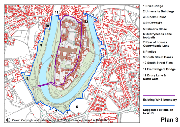
Plan 3 below shows the result from the 2014 review and is intended to provide an initial boundary for further scrutiny and justification if approved following consultation. The boundary includes the areas define din the 2006 Management plan as Bailey, Peninsula and outer riverbanks. This incudes the steep sections of outer riverbank and key access points. It extends to include all of the South St footpath approach with the exception of the recently approved South St/Pimlico housing development. In order to close the boundary across the river the two historic bridges at their full extents have been included. The bridge boundaries avoid including unnecessary buildings to link bank to the Riverbanks. The exceptions are those on the ancient structure of Elvet Bridge and built over the site of the North Gate. Open space links to he river and forming the setting to the listed Dunelm Bridge are included for river access their landscape value and view sot the WHS.
A1.3. Setting
A1.3.1. Describing Setting
The 2016 draft WHS management Plan concludes that the broad area identified for further study as the setting of the WHS is the ‘inner bowl’ as referred to in the 2006 Management Plan. It also concludes that the more distant views are not sufficiently coherently related to allow the creation of a zonal outer setting and this approach depends upon planning policy and practice being sufficiently robust in practice to protect distinctive views and the distant skyline in key sectors.
Ensuring protection against risks to the WHS does not preclude desirable development, indeed appropriate change is essential for the economic vitality and management of the city and can bring benefits to the WHS. Achieving clarity about the setting and views will provide greater certainty when assessing development proposals and will aid the implementation of beneficial changes for Durham.
For historic assets the role of setting is generally defined in relation to the conditions that led to the recognition of significance in that particular setting:
‘The setting of a heritage structure, site or area is defined as the immediate and extended environment that is part of, or contributes to, its significance and distinctive character12’.
In Durham WHS, the significant relationship is primarily visual. Further work is needed on visual impact mapping to clarify the visual relationship of the setting to the WHS.
The previous Management Plan and the special circumstances of the Durham WHS support the definition of Setting. Historic England’s advice is that: ‘Setting does not have a fixed boundary and cannot be definitively and permanently described as a spatially bounded area or as lying within a set distance of a heritage asset13’ .
The concept of ‘setting’ is a positive and useful tool for Durham since it helps to provide clarity about the most sensitive and vulnerable areas. For Durham WHS the significant relationship of the WHS to its setting is primarily visual. Further work on visual mapping, to clarify and define this visual relationship is needed. Each development proposal will need a separate assessment of its impact on this relationship.
The defining topography of the inner bowl is particularly dominant and is not something that will change in the foreseeable future. Even if management practices change, particularly for tree areas or development, the topography will remain a constant in the future.
A1.3.2. Extent of an Inner Setting
The range of options for an inner setting begins with the immediate area surrounding the proposed extension of the WHS and extends to include historic buildings, views and landscape areas of the ‘inner bowl’ as described but not defined in the 2006 Management Plan. It is important to understand the degree of risk to the WHS OUV in relation to the quality of protection that is afforded. This determines the scope for defining an inner setting.
The initial appraisal of the area is shown on Plan 1. This based on field survey and refinement using topographical detail for ridgelines and visibility of the WHS. It extends beyond the City Centre Conservation area to include ridge tops where extensive or high development would degrade green skyline definition. The area shown is capable of being defined due to its clear topographical from. It contains the historic core offering the first level of the skyline in cross views of the WHS, views from it. Many of the historically depicted views are from within this area. Its relative integrity is partly described above in relation to extending the WHS boundary.
Risk is seen as harmful alteration to buildings, landscape or the addition of discordant buildings and development. The potential is for harm to the OUV of the WHS in particular the ‘The visual drama of the Cathedral and Castle on the peninsula and the associations with notions of romantic beauty’ and ‘The physical expression of the spiritual and secular powers of the medieval Bishops Palatine that the defended complex provides;’
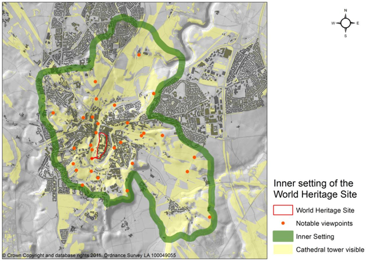
Plan 1 shows the definition of a zone that corresponds to the inner bowl based on topography. It contains the more significant views to the WHS buildings and immediate setting. In defining this zone the other sequential approaches and more distant views are not to be considered of reduced value. The zone offers a means to understand Durham WHS setting and to indicate the need for attention to view assessment and negative impact on the WHS OUV as part of any development proposals.
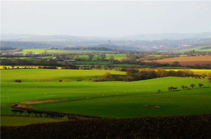
View from the North East from Frankland Lane
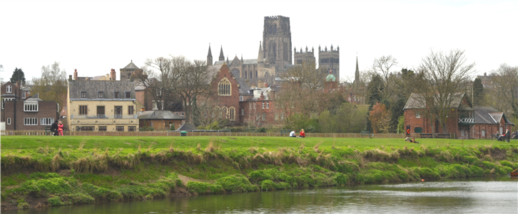
View from the North East overlooking the racecourse
Plan 1—Inner Setting Area
The inner setting ranges from close glimpsed views in the City to those where the townscape can be seen against the WHS and in its landscape setting. The area is expansive, tracking the ridge tops as they run north and south along the River Wear. The relative subordination of the City’s buildings and appreciation of the rural nature of the enclosing landscape are key defining features of the inner setting.
These qualities reinforce the site’s outstanding universal value and remain important in appreciating the WHS and require careful consideration when development is proposed.
View from the East
A1.3.3. The Value of a Outer Setting
The UNESCO World Heritage Resource Manual, Preparing World Heritage Nominations (Second Edition, 2011) usefully summarises the value of the wider setting;
Pg. 85-86, Wider setting (Particular relevance is highlighted in bold)
In addition to the property and its buffer zone, it can be very important, to consider a further area outside of these – the wider setting for the property. For some properties, the wider setting is an area that may be important for the visual characteristics or attributes of the property. As noted above, the wider setting might also play an essential role in protecting the authenticity and integrity of the property. Examples of development or changes within the wider setting which can adversely impact on the potential Outstanding Universal Value of a property include visually prominent items such as tall buildings or windfarms. These might be a considerable distance from the property and yet could compromise the way the property is understood through the relationship to its setting. In some situations the wider setting and the buffer zone may be the same; in other cases the wider setting may be much larger. A rationale for the extent of the wider setting should be provided, noting this is not formally required by the Operational Guidelines
As the guidance implies, the suite of protective zones is clear but determined by the property and its attributes. The 2006 WHS Management Plan identified the need for mapping both the inner and wider settings as ‘inner’ and ‘outer’ bowl. Significant views were considered but were neither defined nor recommended for further definition or protection.
The ‘outer’ bowl is in reality a succession of slopes, ridges and hills rather than a clearly defined topographical entity. These broadly align with dry valleys or rivers, principally the Wear (See Plan 2A)
The outer setting provides an important backdrop to views of the WHS. Among other developments, the recent expansion of wind turbines could have had a detrimental impact on the setting of the WHS. Rather than define an outer setting, the prevention of harm to views should be a priority as each development proposal is assessed in its own right.
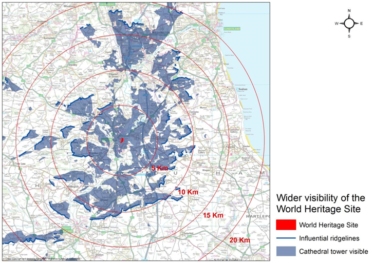
Plan 2A shows these zones and the degree to which the Cathedral Tower is visible without taking into account buildings or trees and is based on topography.
Views cluster within a 10Km radius and up to approximately 12Km. Beyond that the view range is very extensive to the north and higher spurs to the west, including northerly into Sunderland City Council’s administrative area. In reproductions of photographs the WHS presence is minimal, the views above are up to approximately 6Km distance. When viewed in situ the impact is greater and increased potential for negative impact from larger development, such as wind turbines on the horizon. The landscape becomes extensive and open in the view.
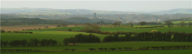
Mid Distance View from the East

Inner Setting View from the East
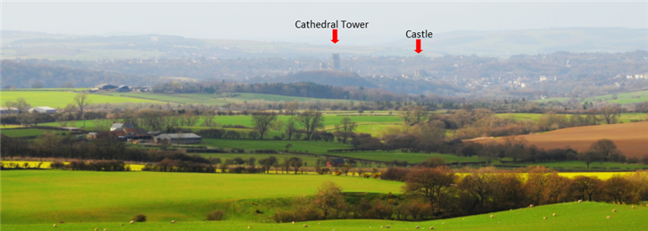
Outer Setting—View from the South East
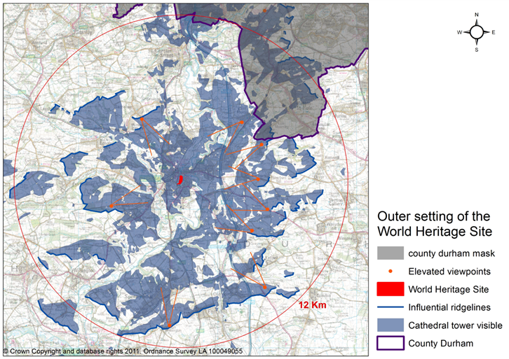
Plan 2B, will need to be further refined on the basis of further analysis but shows an initial approach to the definition of key view zones where views might need to be protected and identifies some of the significant highpoints with views. It also shows areas with potential views to the Cathedral Tower based on topography. Views from within approximately 2.5Km (see below) show more clearly how the WHS buildings dominate the City and the immediate landscape.
A1.3.4. Views, Inner and Outer Setting
It is considered that views of and including the WHS are the principal defining features underpinning describing inner and outer setting. If sight of the Cathedral central tower is set as the criterion for defining views, then the area from which it is visible is extensive, reaching a substantial distance from the WHS. The most important views are those that have historical relevance, including the first views of the Cathedral for pilgrims past and present, and those where both the city and the WHS are seen together in their rural setting. Harm to these views should be avoided based on clear assessment as part of development proposals or other change. The best views include those from the north, along the River Wear from the area around Frankland Farm, and from the south east between Shincliffe and Old Durham.
Views can be ranged along a corridor on an approach to the WHS or can be site-specific from a single point, sometimes at a considerable distance from the WHS. The significant view alignments include those identified below but this list is not comprehensive and other views may be identified.
The actual alignments of the historic approaches to the WHS are, in some cases, conjectural or have been altered by recent highway or other developments. However, most approaches can be identified and include:
- The path from Finchale Abbey, giving views from the valley and from Frankland.
- The coast road from Sunderland, which has views from West Rainton, and from Easington, with views at Sherburn Hill. The road from Houghton-le-Spring also has significant views.
- Bent house Lane to Old Durham.
- The road from the south, giving views from the Spennymoor area, near Coxhoe, at Bowburn and Shincliffe.
- The roads from the west, with good views from Old Brandon and at Ushaw Moor and Bearpark.
- The roads from the north west, at Sacriston and Witton Gilbert
- The road from Chester-Le-Street in the north is an historic approach but does not offer significant views of the WHS.
In addition, several footpaths and smaller roads offer views from higher ground. These are clustered along the scarp of the eastern limestone plateau and the coalfield spurs to the west of Durham
The best views and areas of potential highest impact if development is permitted, are contained within approximately 2.5 kilometre (the inner setting) of the WHS. Middle distance views at a 5 kilometre radius can also be significant with areas also acting as the backdrop in cross views. However, in some cases there is scope for significant impact up to 12 kilometres or more if large developments such as wind turbines are proposed. Some of these areas are outside Durham County Council’s administrative boundaries.
A1.3.5. Skyline and Backdrop
Further towards the upper levels of the ridges defining the inner setting, the coalfield spurs and limestone escarpment start to form the secondary skyline behind the opposite inner ridges. In doing this they also form the backdrop, principally rural or landscape, to the WHS. This is particularly significant in emphasizing the contained area of the historic city and supporting the attributes of the WHS setting and it’s OUV. As landscape or open fields it is valuable also in forming the containment and setting to the historic city.
From a distance, changes within the view corridors are unlikely to have a negative impact if they are at a lower height, not extensive or of low impact in their colouring or reflectivity. Gradual change in landscape or farming practice is also less likely to generate an adverse impact. Potential threats lie in larger scale loss of trees or from more major development. This could be through lower, more extensive built areas or more concentrated taller construction. If agricultural practices were to become more intensive, for instance, through the introduction of polytunnel cultivation, this could be a threat. The risks mostly lie in continuing pressure for windfarms that penetrate the skyline or from housing development that extends the historic area of the city or removes visible open areas. Risks would include, as an example, the extension of the visible built area of historic city core and the removal of open farmed land to the rear of Crook Hall. Currently, pressure for intensified farming practices does not appear to be a concern.
In the context of the WHS, the relative scale of wind turbines on the skyline is not the only impact. The introduction of even a small structure prominently in the view can draw otherwise historical areas of farmland or landscape into the present, creating a non-traditional appearance that has more impact than size alone. Distant views can be forgiving of development that does not force the viewer to contend with a 21st century structure in a landscape that has evolved organically over 1000 years. However, single wind turbine on the skyline can force a much more substantial section of horizon out of its historic relationship. This factor is not considered in standard environmental impact assessments. The same considerations apply to development using contemporary materials that produce higher contrasts of colour or reflectivity.
Distant View from the South East
A1.3.6. Describing and Assessing Impact on Setting
As indicated, it is difficult to define a coherent area as an outer setting. The concentration is on describing views through broad view corridors and skylines
The assessment of impact on those views is through a combination of view analysis and judgment based on heritage assessment. Use of the ICOMOS guidelines on assessment is recommended to ensure the appropriate weighting for the significance of the WHS>
It may be possible to concentrate the assessment requirements to a zone between the inner setting and 12 km from the WHS but further work is needed on a setting report that uses computer aided analysis of WHS heights and visibility, cross checked in the field for impact. Areas outside County Durham may need to be discussed with neighbouring local planning authorities.
A1.4. Key Factors in Active Conservation of WHS OUV and Setting
As part of the review of the WHS and its setting and potential for expansion and setting description, various key factors have been identified. They are principally concerned with the character of the WHS and Peninsula but also have relevance to the landscape setting and townscape that relates to the WHS. The following character elements provide potential reference points for the assessment of proposals that will lead to positive change or new development within the WHS and its setting:
Landscape Character:
The immediate landscape setting of the World Heritage Site, comprising Durham Peninsula and the River Wear and its banks is integral to the value of the World Heritage Site and needs to be conserved and maintained. Woodland management is considered a key factor in the conservation of this immediate landscape setting. The Peninsula on which the World Heritage Site buildings are sited is set within a ‘bowl’ approximately 2 miles across (See section A.1.3.2. Inner Setting). The upper slopes of this bowl present a largely rural and wooded backdrop to the views of the WHS. The rim of this bowl is at such a height that in most distant views from beyond the Bowl towards Durham only the upper part of the central Cathedral tower appears as an indication of the World Heritage Site in the landscape.
Regard should be had to heights of all proposed buildings within the historic city environs to ensure no harm is done to the WHS by development that damages the special relationship between the height of the Cathedral and Castle and their relationship to the overall cityscape and landscape. The Cathedral and Castle need to continue to dominate these to avoid harm to the site’s OUV. For these purposes, the Castle mound should be considered as an integral part of the Castle.
New development should not compromise key views to, from, and of the World Heritage Site, including long distance views (see Section A1. 3.3. Wider Setting). All views should be respected, with particular attention to views from major roads into the city, and public footpaths from which views of the World Heritage Site can be enjoyed. The green space penetrating the and defining the historic city is important in views to, from and across the WHS
Townscape Character:
The character of Durham World Heritage Site depends not only on the major features of the Cathedral and Castle but also on the way in which the surrounding streets and individual buildings collectively create a harmonious urban ensemble in order to support the site’s OUV. In order to maintain this distinctive harmony, new buildings and alterations to existing buildings should recognise and respect the essential characteristics of the existing cityscape.
New development in the World Heritage Site or its setting on the Peninsula will need to respect and relate to the simple, robust shapes, restricted materials palette and ratio of wall to openings of the traditional buildings and be of high quality in order to assimilate into the WHS and to enhance to the World Heritage Site and its setting.
Buildings of a greater mass and density than the traditional vernacular architecture of the immediate vicinity of the Cathedral and Castle are unlikely to be compatible with the historic urban townscape of the World Heritage Site. Large scale development that competes visually with the centrepiece of the Cathedral and Castle is likely to be out of character with the historic, small-scale pattern of the rest of the city. Where substantial development can be justified as essential to sustainability, breaking it into smaller well-mannered elements may offer opportunities for assimilation into the townscape.. The historic urban fabric in the area surrounding any proposed new building provides the general reference for what is an appropriate scale and size and thus what is can be considered to have negative impact in the context of the World Heritage Site.
Where streets in the setting of the WHS are visually, historically and architecturally homogenous, even greater sensitivity is required to ensure that new development does not detract from the strong traditional character. Areas with a high concentration of listed buildings also require a more sensitive approach to ensure that new development does not compromise their integrity and contributes to their setting.
A particular feature of the city centre is the continuity of the buildings running along the Peninsula and continued in the spur along Claypath; this is a feature that could be considered of importance, potentially nationally. The historic profile of buildings and ridge should be maintained to ensure continuity through Saddler Street, The Market Place and Claypath to link onto the WHS and South North Baileys
Because the WHS relies on the surrounding harmonious urban ensemble for its setting, new buildings and alterations to existing buildings should recognise and enhance the harmony of the townscape.
Street Character:
Durham City centre’s status as a conservation area means that the historic building stock has been identified as being of special interest and all new development should conserve or enhance its value. New buildings on the WHS and Peninsula should respond favourably to their immediate context, and not just to the architectural traditions of Durham as a whole. Proper consideration of external areas and the spaces between buildings is essential, as is the relationship between the edge of a building and the public realm.
The character of a street depends on individual buildings, their architectural style, size, height and roofline, typology, massing and form, finishing materials, the proportions and size of doors and windows, architectural details, relationship with neighbouring buildings, and with the public realm, including the street width. New buildings should respect the size/height of neighbouring buildings, as well as the building/façade line will need to respond to the urban character of their environment. Strong-horizontally-proportioned windows, as an example, are normally inappropriate in the context of the World Heritage Site. This does not mean that a pastiche of a historic building is automatically better than an unashamedly modern building; some of the least successful modern buildings in Durham are those which have tried unsuccessfully to copy the traditional building stock.
Traditional approaches to gables, stepping facades in order to accommodate changes in street level, and other architectural details characteristic of historic buildings in Durham should be considered in new development. Buildings with simple traditional roofs and avoiding long continuous ridges or eave lines or the use of reflective surfaces, such as glass, as a roofing material are more likely to be assimilated. The relative proportions of architectural elements (of doors, windows, height of each floor with respect to total building height) are often the determining factor in whether or not a new building fits in with its setting.
The characteristics of the existing historic streets and areas providing the context for new development should be assessed and respected and enhanced, through new development taking the following into account:
- Building Size/Building Line
- Architectural Style
- Architectural Details/Proportions
- Building Materials
- External areas and spaces between buildings
- Edge of building and the public realm
- Lighting
Street Furniture
The harmonious urban ensemble of the Durham World Heritage Site can further be reinforced and supported through a planned and sensitive approach to the introduction and renewal of street furniture throughout the site, taking into account the essential characteristics of the WHS.
Historic street furniture is a feature of the Durham WHS and enriches the streetscape. When planning works to the public realm, care should be taken to ensure that historic objects are not harmed. The legacy of unplanned interventions, leading to uncoordinated street furniture and clutter should be addressed as part of any new planned interventions.
Where new additions/changes to existing street furniture are planned, the aesthetic qualities of the site and existing street furniture should be taken into account. The cumulative effect of minor interventions should be considered when any new additions to the street furniture of the WHS are planned.
Lighting
New buildings can have an impact on the night-time setting for the WHS buildings both lit and unlit. External lighting of buildings would have the greatest impact but inadequate assessment of lighting can allow undue impact from light escape from openings. Public lighting levels are low and many paths are unlit, adding new lighting can have substantial impact by intrusion and design. New developments should be assessed carefully for negative impact on the WHS.
1. WHS Management Plan (2006), Chris Blandford Associates, Fig 2.5 Component areas of the WHS and its immediate environs
2 Purcell Miller Tritton for Durham City Vision (2011), Heritage and Condition Survey of the Castle Walls on the Durham City Peninsula FINAL REPORT
3 Operational Guidelines for the Implementation of the World Heritage Convention WHC. 13/01 July 2013, Annex 4 - Nara meeting on Authenticity at its 18th session (Phuket, Thailand, 1994) (see document WHC-94/CONF.003/16).
4 City of Durham, Lighting and Darkness Strategy, Spiers and Major 2007
5 ICOMOS 1995 Monitoring Report . ‘most of the town when judged in isolation is emphatically not of World Heritage status and indeed is entirely unremarkable’
6 Durham County Council 2006, Landscape Character Assessment
7 Current redevelopment is underway at Freemans Reach and proposed for the Gates Centre and Milburngate House
8 Barrett Environmental, Cathedral and Castle Protected Species Surveys
9 NPPF Planning Practice Guidance: on World Heritage, March 2014, Section 22
10 International Council on Monuments and Site’s (ICOMOS) Heritage Impact Assessment Guidelines,
11 The 39th Session of the World Heritage Committee, Bonn, Germany, 28 June 2015
12 ICOMOS Xi’an Declaration on the Conservation of the Setting of Heritage Structures, Sites and Areas (2005)
13 The Setting of Heritage Assets 2012, Section 2.2. Para. 1, English Heritage Guidance, Under revision